This travel story covers my time in the European Alps circling the famous Tour de Mont Blanc solo. For those that aren’t familiar with this hiking route. It covers a distance of 170 Km passing through parts of Switzerland, Italy and France. Typically it takes people anywhere 7-10 days hiking to cover the full route. There are runners who compete in the ultra marathon on the same circuit that complete it in approximately 32 hours. The route takes in breathtaking scenery; from glaciers and alpine lakes, to forests and wildflowers. It will take you over mountain passes and deep into valleys. Covering an altitude gain of some 10 Km. While that may sound daunting, people break it up into bite sized chunks to match their fitness. I hope you enjoy my account of my solo journey around TMB.

Day 1:
Geneva to Martigny by train
Martigny to Trient/La Peuty by bus
La Peuty to Champex by foot (16 Km)
Elevation Gain: 1069m

I started the day by parting ways with friend, whom I had been travelling with for the past four weeks. I went out for a final breakfast in Geneva. Then I gathered some last minute supplies from the local shops, prior to my train departing mid morning. I left Geneva bound for Martigny via train (two trains to be exact). Once in Martigny, I had to work out where the local bus left from to take me to the mountain village of Trient. This wasn’t the hardest task as the town was rather small and compact. The bus ride took me through the agricultural valley’s of the Canton of Valais. A few mountain passes later, I arrived at Trient. I think calling this a town is a stretch. There was not much to it. My Aunty and Uncle (Sarah and Steve) had scouted the area for me a few week’s earlier and found a refugio (a serviced mountain hut). The refugio was located just outside of town on the river in an area called La Peuty. They were willing to hold onto my larger bag while I hiked. However, it was just before midday and they only opened at 2:30pm! I waited for the two ladies who ran the refugio to arrive, and with the help of some broken English gave them my bag for safe keeping.
The first day’s route was 16 Km long with 1200m of ascent. Due to my late start I knew I had to move quickly that afternoon. The hike out of La Peuty was straight uphill and very steep for an unrelenting hour. Once at the top you crossed the road which has been a feature on versions of le tour de France, as noted by the signs. I crossed into farmland, and traversed along the top of the ridge for the next hour. Once around the other side of the mountain, I started descending into the valley, winding through the trees. I came across my first river crossing and view of the glacier above! On the homeward stretch into the Champex. My accommodation for the night was at Relais D’Arpette, a mountain lodge at the bottom of a glacial valley. I checked into this luxurious building. A side note, some places offer different levels of accommodation options. This one had camping, dorms right up to ensuite private rooms. After a quick shower and a beer it was onto fondue for dinner.
Day 2:
Champex to La Fouly (21 Km)
Elevation Gain: 811m
I started the day with a hearty breakfast and a couple of cups of coffee to wake me up. Then I set out with some other young, early risers and made my way into the town of Champex. After about 15 minutes of walking, Champex opened out as a mountain escape set on a glassy lake! Today’s stage was less mountainous as the previous and was spent walking in and out of small Swiss farming villages.

Most refugio’s offer a packed lunch to take with you on your day’s hike. Today’s lunch spot was spent laying on the long grass in a field overlooking the countryside. I was making good time today, so I spent a little longer relaxing and called my father to check in and give an update.
The second half of the hike that day was much the same, rolling countryside and lush grass. I made good time and reached the town of La Fouly around 2:00pm. My accommodation was on the far side of town set in the outlying hills. On the final stretch up to the refugio, I came across some pure Swiss summer construction. Construction supplies being airlifted via helicopter up to the mountainside construction site!
I was the first to reach the refugio that afternoon and relaxed on the sun terrace with a beer while researching the next stage of the hike. Since I was the first person there I was able to pick the best bunk (bottom and next to a wall and window). The evening meal was spent with some Italians and French, conversation was minimal as there was not much English spoken. I didn’t get much sleep as there was a loud snorer in the room. I made sure I had earplugs for the coming night.
Day 3:
La Fouly To Courmayer (31 Km)
Elevation Gain: 1305m
An ambitious double stage day was on the cards today as I had made the decision to rendezvous in Chamonix with some friends for Bastille Day. This meant I had to do a double stage in order to reach Courmayer. Noting the last bus was at 5pm. Nothing like a good old challenge. As such, I rose early partly due to wanting to get out of the communal bunk room and away from snorlax, but mainly to get on the road early. I was a little early for breakfast, but was able to be the first one in the showers. Always a good thing in hut lifestyle as they only get cleaned once a day.
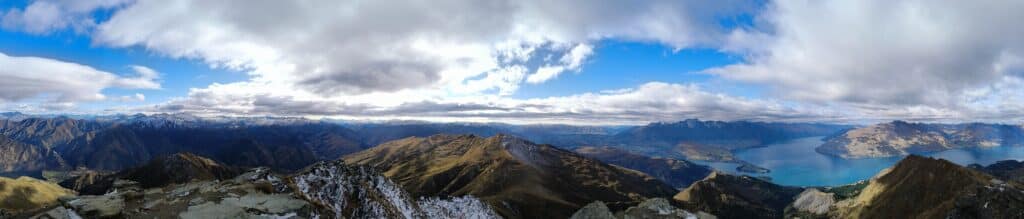
The days’ hike started by meandering along the river. Iit didn’t take long for it turn away and head up the adjacent hill towards the town of Ferret. As I was full of energy at the start of the day, I was setting a cracking pace up the fire trail, gaining altitude rapidly. I soon found my way to La Puele, a lovely hut set on the side of the mountainscape. From here I put my cold weather gear on (thermals, gloves, hat, beanie, bottoms to my pants and windbreaker), I set off for the top of the pass. I was still climbing up into the cloud line and getting glimpses of snow-covered hills. I was encountering a series of endurance runners coming from the opposite direction. Presumably undertaking some training for Tour Du Mont Blanc Ultra Marathon. After plenty of snow packs and frozen river crossings, complimented by howling winds, I made it to the summit of the Grand Col Ferret (2537m). I didn’t stay for long as the temperature was in the negatives. So unbeknownst to me, I set off into Italy.

The descent into the valley was a downhill rock scramble for the first hour. I did not envy the hikers ascending and my 50/50 guess on the which direction to circuit the TMB had paid off! Once off the sides of the steep peak, the valley opened up to reveal a narrow sprawling valley adorned by multiple glaciers looking back at me. I took a well-earned break overlooking these glaciers and taking it all in.
After around an hour or so I had descended completely onto the valley floor. Temperatures here were well into the mid-twenties and rising. Whether it was a case of reverse vertigo or me taking my mind off the job for a second, I had lost the hiking trail…So I was forced to hike along the roadside and work out the best place to cut back onto the hillside. Using a combination of google maps, and the useless paper maps I had picked up I tried to find the quickest route. As luck would have it my “expert” navigation skills were the best asset and I spotted a trail on the hillside snaking its way up onto the ridge I needed to be on, so I set forth. I made the ridgeline without too much trouble and soon it was lunch time. Once there I found a nice grassed crest overlooking the mountains on the other side of the valley. I thought I would see where this famed “Mont Blanc” lay, alas my trusty google map was saying it was behind me. So I lay in the grass, basking in the sunshine enjoying my cut lunch overlooking this “Non-Mont Blanc” mountain, it was bliss.
Back on my merry way, and no less than 10 minutes after lunch. I turned a corner and came across a compass, pointing to all the surrounding peaks. Everyone was getting a photo with my lunchtime mountain in the background. I went to investigate, there it was Mont Blanc, google maps failing me again (insert hand slapping face emoji). I took my place in line and asked a fellow hiker to capture me and the famous snow covered peak.
Insert photo of me and Mont Blanc.
Once I had finished with my photo op, I rounded the peak and found Courmayeur DIRECTLY below me. This was going to be steep! This was the toughest 5 Km of the whole hike. It was hard on my knees, hard in the heat and hard after the hiking and climbing I had already done. Courmayeur, while in the Alps is a relatively large city. Once on the outskirts, I had to employ my trusty google maps (for it’s urban benefits) to get me to the main bus station. I reached the bus station at 2:30pm, around 7.5 hours on the foot falcon and reaching the goal of not missing the last bus achieved. The bus was at 4pm, so I treated myself to an ice cream and coke!
Bus from Courmayeur to Chamonix and Bastille Day:
I purchased my ticket at the bargain price of 5 EUR to take me through the Mont Blanc Tunnel and drop me in France for Bastille Day festivities. The tunnel itself was a masterpiece (me being a civil engineer). Stats on Mont Blanc Tunnel, traffic.
Once I had settled into my accommodation and rinsed of the day’s grime, it was off to meet up with Stevie G and the gang for some beers and food. We sat on the main plaza and soaked up the atmosphere of the national holiday’s festivities. After dinner we got involved in the street party festivities, live music and drinks on the streets. ABSOLUTE SCENES!
Day 4:
Rest Day Chamonix
The plan was to do the Southern section of the TMB around this time, however due to the remoteness of this section and coinciding with Bastille day, accommodation options were non-existent. So, I decided to have a lay day in Chamonix and let my blisters heal. I stayed at the legendary party resort ‘La Foulie Duece’. Being the day after Bastille day however it was a more subdued atmosphere. I chose to lounge by the pool and catch up with some friends via video chats. Chamonix is an outdoor paradise. Known for both summer and winter sports there is something for everyone to enjoy here. I was lucky enough to stumble across the world championships of speed rock climbing. Quite an interesting watch!
Day 5:
Planpraz (Chamonix) to Vallorcine (18 km)
Elevation Gain: 528m
This day started a little differently than the previous days. I walked through Chamonix as it was waking up and made my way to the base of the Planpraz gondola. This took me from the centre of town up to the top of the ridge at 2000m elevation in just a few minutes. Once here I proceeded to make my way north with stunning views of the Mont Blanc Massif. I was weaving my way through ski slopes and lift infrastructure. This all looks very different in summer compared to winter. I stop for a few minutes to watch the construction of a new chairlift structure. Seeing tower cranes on the top of a mountain side at this altitude was spectacular!

After the ski slopes had finished the countryside turned more rocky. The ground was interspersed with grass knolls and rocky outcrops as I kept rolling downwards towards the valley floor. I finally made my way off the side of the mountain and was out of the whipping wind. Once again in calm, warm sunshine. Time for a spot of lunch. After a good stint of basking in the sunshine while my food digested, I made tracks for Vallorcine railway station. The journey followed the creek towards the train station, where I had made good time, so treated myself to a cold beer while I waited for the train.
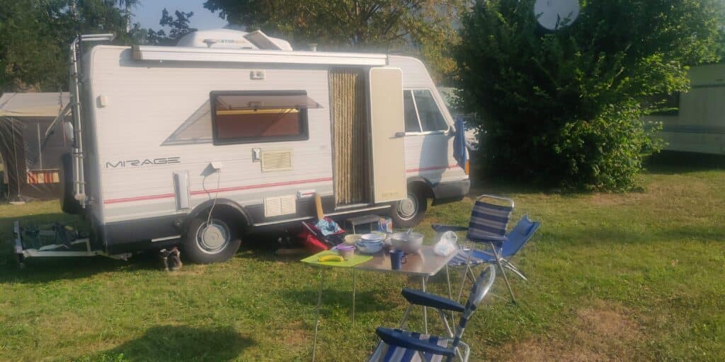
The train ride was spectacular in its own right. Winding down through the valley, tracks perched on the sides of steep cliffs and ducking in and out of tunnels. Once at Vallorcine, I found my Aunty Sarah, her father Laurie and my uncle Steve waiting for me! The plan from here was for Steve and me to take the campervan for a couple of nights while Sarah took her father back to Zurich to catch a plane back to Malta.
Steve and I made a quick pit stop at the supermarket, picking up the essentials of bread, beer and cheese! Then we were headed back to my starting point of La Peuty where my bag was being stored (fingers crossed) to park up for the night.
It was a short drive over the range and down into La Peuty. We found a nice spot and positioned the camper window looking up the valley toward the Trient glacier. We set up camp and cracked a cold beer! When the refugio opened, Steve went over to do the dealings. Given the part of Switzerland we were in (French) Steve was the best candidate to do the talking. He said he didn’t know too much French. However he was able to converse for a good while, cracking a few jokes with the ladies and track down my bag as well!
Day 5:
Le Bre`vent (Chamonix) to Les Houches (16 km)
Elevation Gain: 361m
After breakfast we packed up the campervan and made our way back to Chamonix to do a section of the TMB heading South from Chamonix. We caught same gondola up to Planpraz I had done on day four. Then continued up another gondola to Brevent (2532m) for our starting point for the day. We stepped off the gondola and had amazing views of Mont Blanc, which Steve informed me is a rarity in the Alps. As such we stopped for a photo op of us with the mountain in the background. Right on cue as soon as the photo was taken, cloud engulfed the peak and the opportunity gone!
Insert photo of me and Steve overlooking Mont Blanc.

We made our way down off the peak and Steve had his eyes set on a dip in an alpine lake a little way below. I was less convinced but was happy to watch. Once he was refreshed we continued to make our way along the ridge line with 360 degree views to take in. After a couple of hours of hiking we found a grassy ridge for lunch Overlooking Mont Blanc, with Chamonix below. We made our platter of cured meats, cheese, bread and salad and tucked in. After lunch we had a snooze in the sun and took in more of the views.
Once we were back ready to go, we headed down towards the valley, checking our directions every so often to make sure we were on the right path. We found ourselves aiming for Lac Blanc for an afternoon dip. However on arrival it was deemed it wasn’t really a swimming lake. So we kept going towards the Les Houches train station in hope we could have a dip in the river. However that was not meant to be either. We caught the train back to Chamonix and missed out on paying a fare as we only went one stop! Once back at the campervan and headed for La Peuty again for the night. We found a similar spot and set up camp for the night. Prior to having a beer Steve and I went to the river in search of a spot for a dip. Success! We found a shallow pool to rinse off and refresh ourselves, the water was icy as it was running straight off a glacier, however the day was complete.
Day 6:
La Peuty to Trient Glacier (11 km)
Elevation Gain: 662m
We decided to leave the camper parked up and hike up towards the Trient glacier. We made our way up the valley with the glacier towering above us. We veered off from the main TMB route and continued to follow the glacial river. After a time the bush became very dense and we decided to head back towards the river. We kept pushing up the river doing some crossings. The further we went, the bigger the crossings became. Finally our luck ran out and we could go no further. With the glacier ominously looking down on us, we took in the view and headed back down the river. We made it back onto the TMB trail and found a nice little refugio for a slice of cake and a beer. Heading back to the campervan, we made it by mid afternoon. Ready to hit the the road again and rendezvous with Aunty Sarah. The TMB was complete for me.
3 countries, 113 km over five days!
Total elevation gain of 4736m.